Australia — Wine Region Guide
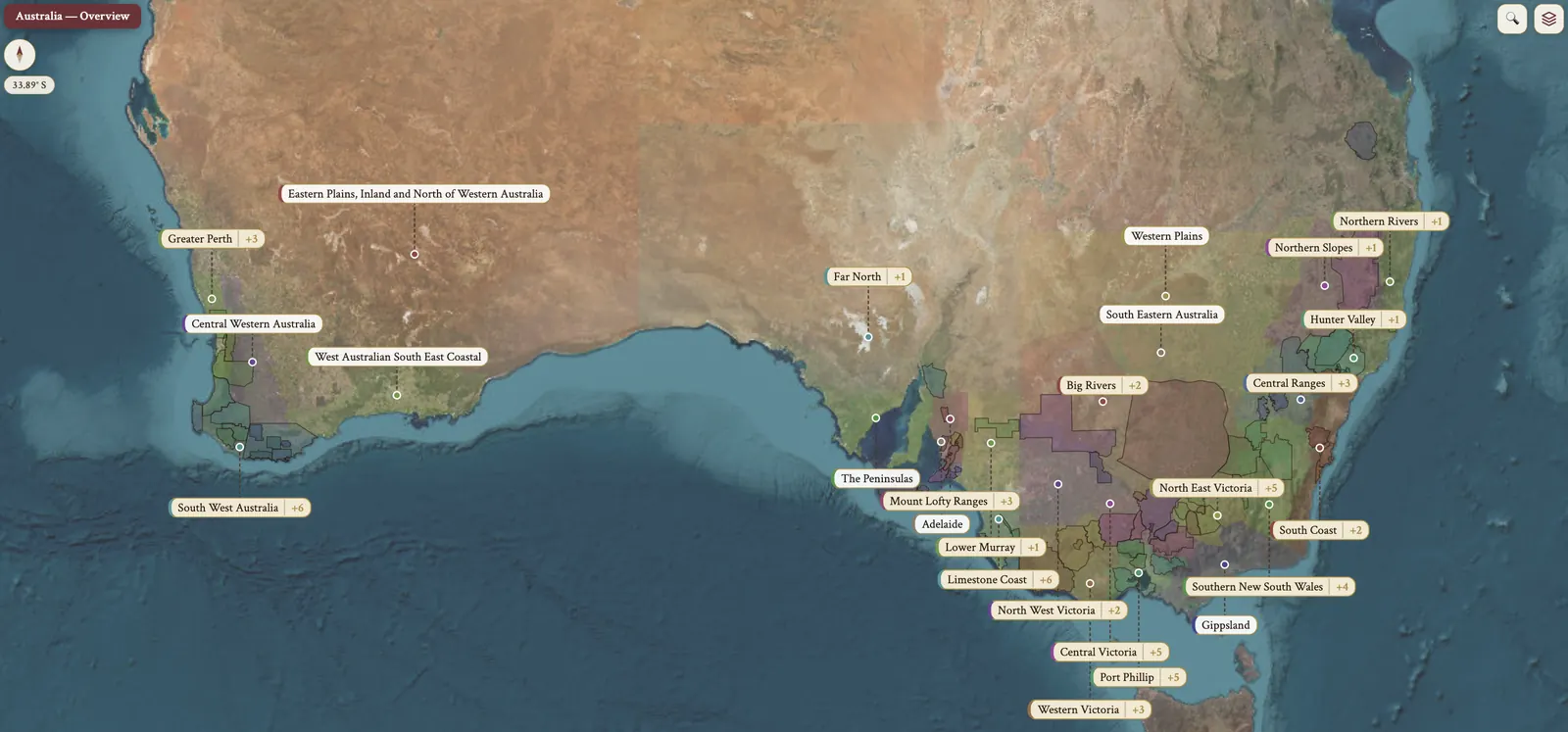
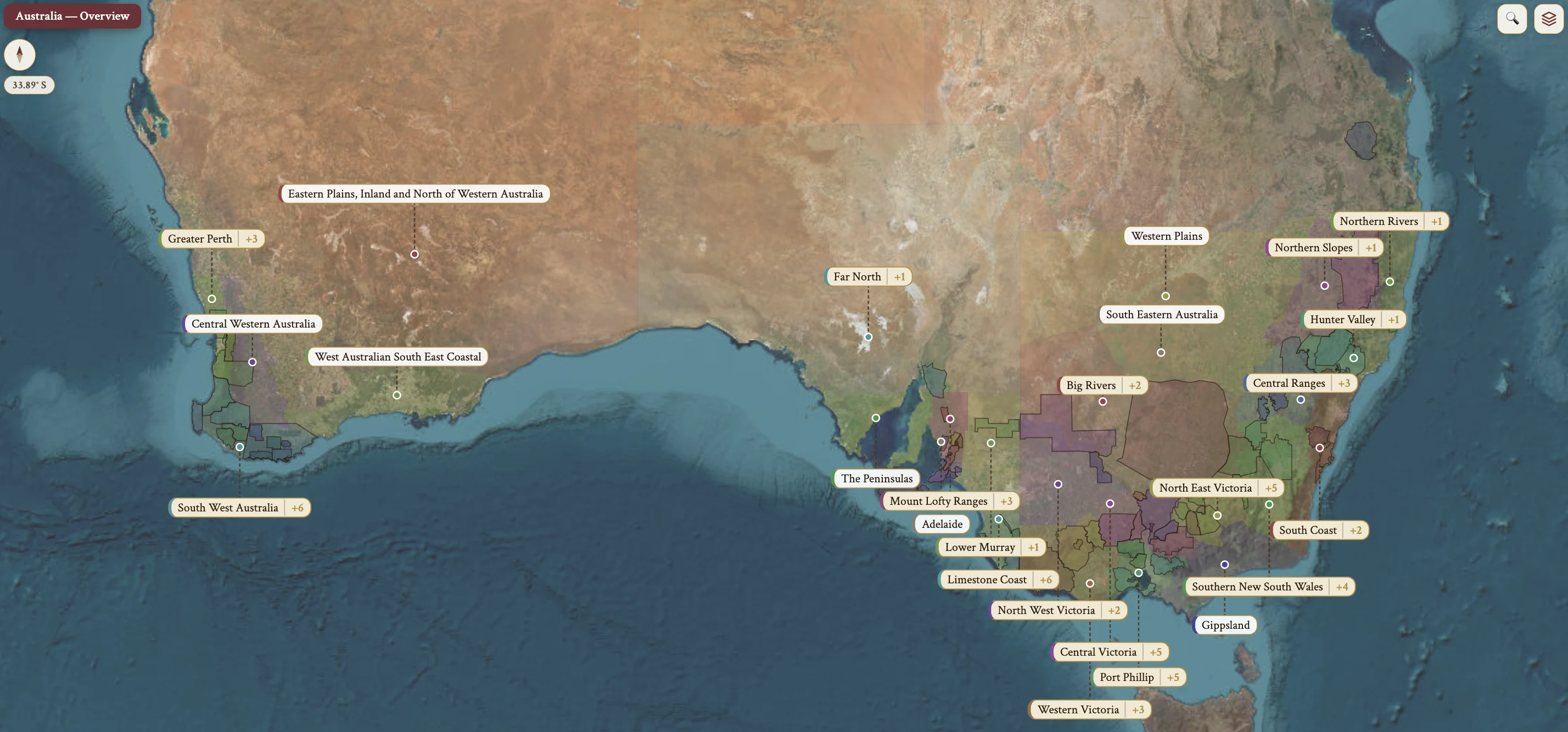
The Australia maps from Your Own Wine Encyclopedia — every name tag opens a study card. Below, the chapter's own geography, climate and geology notes.
From the encyclopedia
Australia — National Overview
Australia is the 5th largest wine producer in the world, averaging 12.7 million hL/year over 2017–2021, and it sits regularly 5th–7th alongside Argentina and Chile. It is also the 5th largest wine exporter by value and volume.
There are 6 wine-producing states: SA, NSW, Victoria, WA, Tasmania and Queensland. South Australia alone accounts for about 50% of national production, and SA, NSW and Victoria together make up about 97% of the crush.
By harvested fruit weight the top 5 plantings run Shiraz, Chardonnay, Cabernet Sauvignon, Merlot, Sauvignon Blanc. On phylloxera status the country is split: the insect is present in parts of Victoria and NSW, while SA, WA and Tasmania remain phylloxera-free. Screwcap closures have been almost universally adopted, even at the premium tier, the notable exception being Penfolds "Grange".
History — the First Fleet and the spread of the vine
In 1788 Captain Arthur Phillip landed the First Fleet at Botany Bay, south of Sydney. Vine cuttings collected en route at the Cape of Good Hope were planted near Sydney, founding the colony of New South Wales.
From NSW the vine spread outward: Tasmania in 1823, Western Australia and the Swan River Colony in 1830, South Australia in 1837, Victoria in 1838.
The family founders of the 1840s that are still operating are Lindeman's in 1843, Penfolds in 1844, Orlando Wines in 1847 and Yalumba in 1849. The 1850s gold rush triggered massive European immigration, especially to Victoria, and Victoria became Australia's largest wine producer by the 1870s.
History — phylloxera, Federation and the fortified century
Phylloxera in the late 19th c. ravaged Victoria but was contained to Victoria and a small Sydney foothold by strict quarantine. The 1901 Federation of six colonies abolished interstate trade barriers, and South Australia surged ahead of Victoria; it remains the top-producing state today.
From the post-phylloxera years to the 1960s about 80% of Australian production was sweet, fortified wine. That share fell below 40% by 1972 and to less than 0.02% by 2011.
Maurice O'Shea founded Mt. Pleasant in the Hunter Valley in 1925, producing some of Australia's first varietal-labeled wines.
History — Grange, Hill of Grace and the export era
Max Schubert, Penfolds Chief Winemaker from 1948 to 1975, introduced Grange Hermitage with the 1951 vintage; it has been known simply as "Grange" from the 1990 vintage onward, renamed under EU GI pressure when the "Hermitage" name had to be relinquished. The Penfolds Chief Winemaker succession runs Max Schubert (1948–1975), Don Ditter (1975–1986), John Duval (1986–2002) and Peter Gago (2002–present).
Henschke "Hill of Grace" Shiraz was first produced in 1958, and is Australia's pre-eminent single-vineyard wine.
Total production surpassed 1 billion liters by the 2001 harvest. By 2007 Australia had become the 4th-largest wine exporter by volume, behind Italy, Spain and France, with exports surpassing A$3 billion. Severe drought affected the 2003, 2006, 2007, 2008 and 2009 vintages, breaking with substantial 2010 rainfall. The 2008 GFC and a strong Australian dollar damaged super-premium exports, and "critter" labels such as [yellow tail] hurt brand reputation in the US.
Climate — sunlight, cooling and the Winkler Scale
Australia's vineyards lie at low latitude, 30°–37°S, with Tasmania the exception at 41°–42°S. That intense sunlight gives riper fruit and thicker skin. The range of climates runs from hot continental in the Murray-Darling to cool maritime in Tasmania. Most regions rely on a cooling influence close to the coast — the Indian or Southern Ocean — or on high altitude. Spring frost in the cool regions calls for careful site selection.
The hot, warm, irrigated flat plains inland give high-yield fruit, some of it overripe or jammy in flavor. It may be fruit-forward, and it lacks complexity. It can be blended with grapes from cooler regions for a more balanced, complex wine.
A quick reference on the Winkler scale, region by region: Yarra Valley is Region I, the coolest mainland; Coonawarra is Region II, moderate and Bordeaux-like; Clare Valley is Region II–III, warm days and cool nights. Barossa Valley is Region III, warm; McLaren Vale is Region III, warm maritime; Margaret River is Region III, warm maritime; Rutherglen is Region III, warm continental. Hunter Valley is Region IV, hot and humid.
Topography & Geography
In national terms Australia is the 6th largest country in the world, and much of it is too hot for viticulture. The vineyards are concentrated in South Australia, Victoria, NSW, Tasmania and Western Australia — the states with cooling effects.
Flat topography in many areas lets the cooling influence of ocean be delivered far inland. Coonawarra is the example: a maritime climate 100 km from the coast.
The Great Dividing Range is a complex of mountain chains running along the entire east coast. It provides altitude and a cooling effect in Orange, Macedon and the Grampians, and it creates a rain shadow effect — Hunter Valley at 750 mm against Riverina at 450 mm. Its highest section is the Snowy Mountains, within the Southern NSW zone, the highest mountains in Australia. Moderate temperature with that cooling effect lets the vines retain acidity, and the wines are well-balanced and rising in quality.
Soil
Australia is one of the oldest continents, and its geology and soil types are very complex. Coonawarra has terra rossa, a red soil. McLaren Vale has 40 unique soil types, varying in age. Margaret River has gravelly, free-draining soils, iron-rich and known locally as laterite.
Soil salinity is the recurring problem. Its causes are drip irrigation or saline water in deeper aquifers, with insufficient rainfall to wash it through. The effects run in sequence: it becomes more difficult for vines to get water, vine growth is reduced, and the vine dies. Chardonnay is particularly sensitive. Treatments are rootstocks and adjusted irrigation patterns, supplying larger volumes at less frequent intervals.
Grape Varieties — origins and the order of plantings
The origins of Australian grapes lie largely with James Busby, whose cuttings came from Europe in 1831; the detail belongs to NSW and its wine history. European immigrants, notably Italians, have introduced additional varieties. Nurseries and vine improvement schemes are continually trialling new varieties.
Production of 'alternative varieties' has increased, suited to warm and dry regions — Tempranillo, Sangiovese, Fiano and Assyrtiko among them.
By harvested fruit weight the top plantings run Shiraz, Chardonnay, Cabernet Sauvignon, Merlot, Sauvignon Blanc, Semillon, Muscat Gordo Blanco, Colombard, Pinot Noir, Riesling. Black grape varieties comprised 55% of the harvested fruit weight in 2021.
Grape Varieties — Shiraz
Shiraz is the most planted grape variety in Australia and made up 25% of total crushed fruit weight in 2021. It has been highly successful in export markets and is considered Australia's flagship variety.
It is late budding and mid-ripening, and vigorous. It is susceptible to mite, botrytis and Syrah decline disorder, and prone to reduction. It is adaptable, planted in most of Australia's wine regions and providing a range of styles. From hotter regions such as Barossa Valley and McLaren Vale it is full-bodied, high in alcohol, high in soft tannins, with pronounced dark fruit aromas and earthy and spicy notes; it develops leathery characteristics with age. From cooler regions such as Yarra Valley and the Grampians it is less full-bodied, medium in alcohol, less intensely fruity, with red and black cherry flavors and a distinct black pepper characteristic.
The trend is a shift towards less intense, more approachable styles. That is achieved by reducing extraction, by whole bunch fermentation, which is increasingly used, and by reducing levels of new oak; French oak is increasingly used over traditional American oak. Very good and outstanding quality Shiraz is given manual or mechanised punch downs for soft tannin extraction, and is made in open fermentation tanks.
Three blends recur. GSM is Grenache, Shiraz, Mourvèdre/Mataro. Shiraz-Viognier is co-fermented for premium wines, similar to Côte-Rôtie, and blended post-fermentation for cheaper wines. Shiraz-Cabernet Sauvignon adds softness and body, similar to Merlot's role in Bordeaux.
Grape Varieties — Cabernet Sauvignon, Merlot and Pinot Noir
Cabernet Sauvignon grew rapidly in popularity in the 1980s as Australia looked to export markets, and was overtaken by Shiraz in the 1990s. It is still capable of producing outstanding single varietal wines and blends, with the other Bordeaux varieties and with Shiraz. It is higher in acidity and tannins than Shiraz, with ripe black fruit aromas of blackcurrant and cherry, and oak characteristics especially at higher price points. Cooler climates give more pronounced acidity and structured tannins; warmer climates give riper fruit characteristics. Two regions are key. Coonawarra gives distinctive mint or eucalyptus aromas; Margaret River often blends it with Merlot, slightly riper with more subtle herbal notes.
Merlot is widely used in blends, especially with Cabernet Sauvignon. Single-varietal wines range from medium-bodied with medium tannins and red fruit to fuller-bodied with riper, black fruit aromas. Quality is improving with the introduction of better clones in recent years.
Pinot Noir sits in the cool and moderate regions — Yarra Valley, Mornington Peninsula, Tasmania. It is medium-bodied, medium in alcohol, medium to high in acidity, with red fruit flavors of cherry and strawberry. Winemaking uses whole bunch fermentation for enhanced aromas, cold maceration to boost color and flavors, and stem inclusion to influence tannic structure. Maturation is in French oak, with a trend towards reduced use of new oak.
Grape Varieties — Grenache and Chardonnay
Grenache comprises only 1% of the total harvested fruit weight in 2021. It is small in volume but important to Australia. Until relatively recently it was mainly used in Rhône-style blends; single varietal Grenache has been increasing, on the recognition of high fruit quality from old bush vines in McLaren Vale, Eden Valley and Barossa Valley. The traditional style is low in acidity, high in alcohol, jammy in fruit, matured in new oak. The modern style aims for greater freshness, higher acidity, slightly lower alcohol and fresher red fruit flavors, sometimes with whole bunches or stem inclusion, and maturation typically in old oak or large barrels.
Chardonnay is the most planted white variety in Australia and is found in almost every region. The evolution of style is easy to trace: in the past it was ripe with overt oak flavors, and the current trend is to pick earlier for a leaner style. Inexpensive wines are tank-fermented, sometimes with oak influence from chips, staves or reused barrels.
High-quality Chardonnay holds a middle ground style: ripe fruit of citrus and peach balanced by M to M(+) acidity, with well-integrated oak. The techniques are ambient yeasts, high solids in fermentation, barrel fermentation, lees aging and barrel maturation, typically in French oak. Malolactic conversion is blocked in warmer areas to retain acidity and carried out in cooler areas to reduce acidity and increase complexity and body. In inexpensive wines Chardonnay is often blended with Semillon.
Grape Varieties — Sauvignon Blanc, Pinot Grigio and Semillon
Sauvignon Blanc is widely planted in both cooler and hotter regions. Cooler regions such as Adelaide Hills produce mid-priced wines; hotter regions produce inexpensive wines with higher yields. The fruit characteristics are intense, ranging from citrus to tropical, and less herbaceous than Marlborough. It is typically fermented in stainless steel, with optional lees contact and barrel fermentation in used oak for fuller-bodied wines. In Margaret River it is often blended with Semillon to produce Bordeaux-style blends.
Pinot Grigio and Pinot Gris divide by picking date. Lighter styles are early-picked for a neutral style, Veneto-influenced. The riper style is picked riper for a fruitier, spicier, fuller-bodied style, Alsace-influenced, though rarely as full-bodied. The finest wines come from Victoria, particularly Mornington Peninsula, and from Tasmania.
Semillon is often blended with SB and CH. As a single varietal in the Hunter Valley it is low in alcohol, high in acidity and unoaked, fairly neutral in youth, developing aromatic complexity with 5–10 years of bottle age — toast, honey, hay. Barossa Valley Semillon was traditionally fuller-bodied with higher alcohol and oak maturation, with a trend towards a lighter style through earlier picking and minimal oak influence. Sweet wines come from noble rot-affected sites in Riverina, New South Wales, De Bortoli among them, and they are complex.
Grape Varieties — Riesling, Muscat Gordo Blanco and Colombard
Riesling is growing in the cooler regions. Clare Valley and Eden Valley are the two notable regions, and it is increasingly planted in Great Southern, Canberra and Tasmania. It is mostly bone dry with high acidity, and its flavors range from apple, lemon, grapefruit and lime to peach. It is fermented in stainless steel and bottled soon after, to preserve vibrant fruit and floral aromas. Premium wines are made with free-run juice, high in sugar and acidity, low in phenolic compounds; some experimentation with pre-fermentation skin contact and lees aging adds texture and weight.
Muscat Gordo Blanco — Muscat of Alexandria — and Colombard belong to the hot, inland regions of Riverland, Murray-Darling and Riverina. Colombard is a neutral, cheap blending partner with varieties like Chardonnay in inexpensive wines, and its plantings have been decreasing over the last 10–15 years. Muscat Gordo Blanco is used in still wines and in sparkling Moscato wines; its plantings are also decreasing.
Viticulture — favorable conditions and mechanisation
The favorable conditions are plenty of intense sunshine, relatively low rainfall, and low humidity in many regions, which reduces disease pressure. Grape ripening is reliable most years, except during extreme conditions such as the wet year of 2011.
Wide vine spacing and flat or gently sloping land facilitate mechanisation. High unit labour costs and remote regions necessitate it. Mechanical harvesting was adopted from the 1970s, and mechanical pruning, hedging and fruit thinning are all common.
The minimal pruning concept was developed by CSIRO in the 1970s and relies on a vine's natural self-discipline. It was adopted widely in warmer areas, and was later criticized for lackluster quality, particularly in Coonawarra.
Viticulture — irrigation, RDI and PRD
Most vineyards rely on irrigation for even ripening and quality protection. The sources vary: rivers of the Murray-Darling Basin; stored rainwater in dams in the higher winter rainfall regions of Adelaide Hills and Margaret River; underground water sources in McLaren Vale and Coonawarra; and recycled wastewater from southern Adelaide in McLaren Vale. Efficient irrigation systems such as drip irrigation are encouraged, and sustainable water sourcing and usage are prioritized. Wasteful flood and spray systems were replaced with drip from the 1960s.
Regulated Deficit Irrigation, RDI, was developed in Australia in the 1980s–'90s. It lowers the total applied irrigation water during key stages of vine development, and it is particularly useful for red grapes, limiting vegetative growth, enhancing fruit color and restricting berry size. The drawbacks are that it may lower yield and slow the accumulation of monoterpenes in aromatic varieties.
Partial Rootzone Drying, PRD, is also Australian-developed. It alternates drip irrigation from one side of a vine row to the other, so half the rootzone is irrigated and half is dry. It reduces total water use by up to 50% without greatly affecting yield.
Viticulture — vigour, humidity and sustainability
Enough heat and water give vigorous growth, and vigor control is there to ensure even ripening, especially on fertile soils. Old vines in South Australia naturally combat high vigour. Divided canopy systems — Scott-Henry, Smart-Dyson — manage vigour for young vines.
Humidity is low in most areas, which reduces rot and mildew. The higher humidity regions — Adelaide Hills, southern Victoria, Hunter Valley, parts of Tasmania — require open canopies to maximize air flow. Warm, dry climates support sustainable viticulture.
Sustainable Winegrowing Australia is the national sustainability program. As of spring 2020 its members owned about 25% of vineyard land and accounted for 25% of production.
Hazards
The hazards begin with spring frost in the cool regions, which makes careful site selection necessary. Wind from the ocean may disrupt fruit set. Drought means low rainfall, which pushes up the cost of water for irrigation and leads to wild fire.
Bush fire is a category of its own. Hot, dry summers increase the risk, and smoke taint imparts a pungent, bitter flavor to grapes. Hand harvesting is recommended in Barossa as a way to reduce smoke taint, since it allows selection of unaffected fruit.
Phylloxera is present in parts of Victoria and New South Wales. South Australia, Western Australia and Tasmania are phylloxera-free, due to strict biosecurity. Original European planting material pre-dates the phylloxera outbreak, and newer vineyards use selected rootstocks for insurance against phylloxera and soil issues.
Birds are treated with netting, which is expensive and adds cost. For kangaroos there is no solution.
Harvesting
The climate leaves a narrow window for optimal ripeness, so harvesting must be rapid and efficient. Mechanical harvesting is the major method: it covers large areas quickly and delivers grapes to the winery quickly, often at night, and modern harvesters keep the grapes whole. Hand harvesting is used for expensive wines, where it limits grape splitting and crushing, allows greater fruit selection, and maintains whole bunches for specific winemaking processes.
Winemaking — production range, education and research
Australia produces wine at all price points: the wine production range runs from inexpensive, high-volume wines to super-premium, small production wines. Both small wineries and large companies produce high-end wines.
Education and research sit behind that. Many viticulturists and winemakers are trained in Australian wine schools, with the first enology diploma in 1936. They benefit from the research of the AWRI, the Australian Wine Research Institute, in Adelaide. CSIRO — the Commonwealth Scientific & Industrial Research Organization — is also based in Adelaide, and the University of Adelaide has an acclaimed oenology program. Australian winemakers gave rise to the term "flying winemakers".
The AWRI sequenced the genome for Dekkera bruxellensis, Brettanomyces, in 2011. It discovered the link between the sesquiterpene rotundone and the peppery aroma of Syrah. It has carried out research into smoke taint, a major issue in wildfire-prone Australia, and it developed commercial yeast strains producing undetectable levels of hydrogen sulfide.
Winemaking — the evolution of style
The evolution of style falls in three phases. In the late 20th century Australia excelled in producing full-bodied, ripe, fruity wines — well-equipped wineries, scientifically trained winemakers, scrupulous hygiene, use of new oak, ripe healthy grapes.
In the 2000s riper fruit and vanilla, coconut oak flavor gave an easy drinking, accessible style, and that brought success on the export market.
In recent years the styles have been evolving and diversifying. In the vineyard that means site selection, vineyard management and precise harvesting dates. In the winery it means experimentation with ambient yeasts, skin contact, lees contact and solids in fermentation, and whole bunch and stem inclusion for reds.
Winemaking — screwcaps, the Stelvin closure and other rules
Australian winemakers have widely adopted screwcaps, and the vast majority of wines, even premium ones, use them. The first truly premium wines released under screwcap anywhere in the world came from a group of producers in Australia's Clare Valley in 2000. In 2013 James Halliday recorded 99% of Australian white table wine and 98.8% of red table wines under A$20 using screwcap. The notable exception is Penfolds "Grange", which continues under natural cork. Australia developed bag-in-box technology in the 1960s.
Stelvin is the brand name commonly used as a synonym for "screwcap" in Australia. The Stelvin closure combines the screw cap itself, the BVS — Bague Vin Standard — glass-finish neck, a tailored liner, and a headspace and capping protocol. Liner choices control oxygen ingress and the aging trajectory.
"Taming the Screw: A Manual for Winemaking with Screw Caps" is the landmark 2005 reference book on screwcap winemaking. Jeffrey Grosset of Grosset Wines in Clare Valley was a contributing editor, and Clare Valley led the Australian screwcap movement.
Three other winemaking rules stand. Chaptalization is illegal throughout Australia. Acidification with tartaric acid is legal and routinely practiced for warm-climate wines, Rutherglen Muscat and Barossa Shiraz among them. For sparkling wine, carbonation is not permitted as a production method when the label states "sparkling wine".
On the map
- All GI zones (incl. outback)
- South Australia
- Victoria
- New South Wales
- Western Australia
- Queensland
- Tasmania
- Barossa Valley
- Clare Valley
- Adelaide Hills
- McLaren Vale
- Coonawarra
- Yarra Valley
- Mornington Peninsula
- Rutherglen
- Hunter
- Canberra District
- Riverina
- Margaret River
- Great Southern