Austria — Wine Region Guide
The Austria maps from Your Own Wine Encyclopedia — every name tag opens a study card. Below, the chapter's own geography, climate and geology notes.
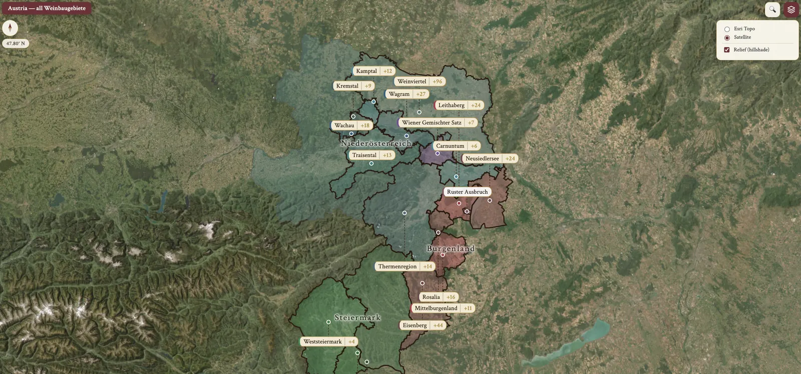
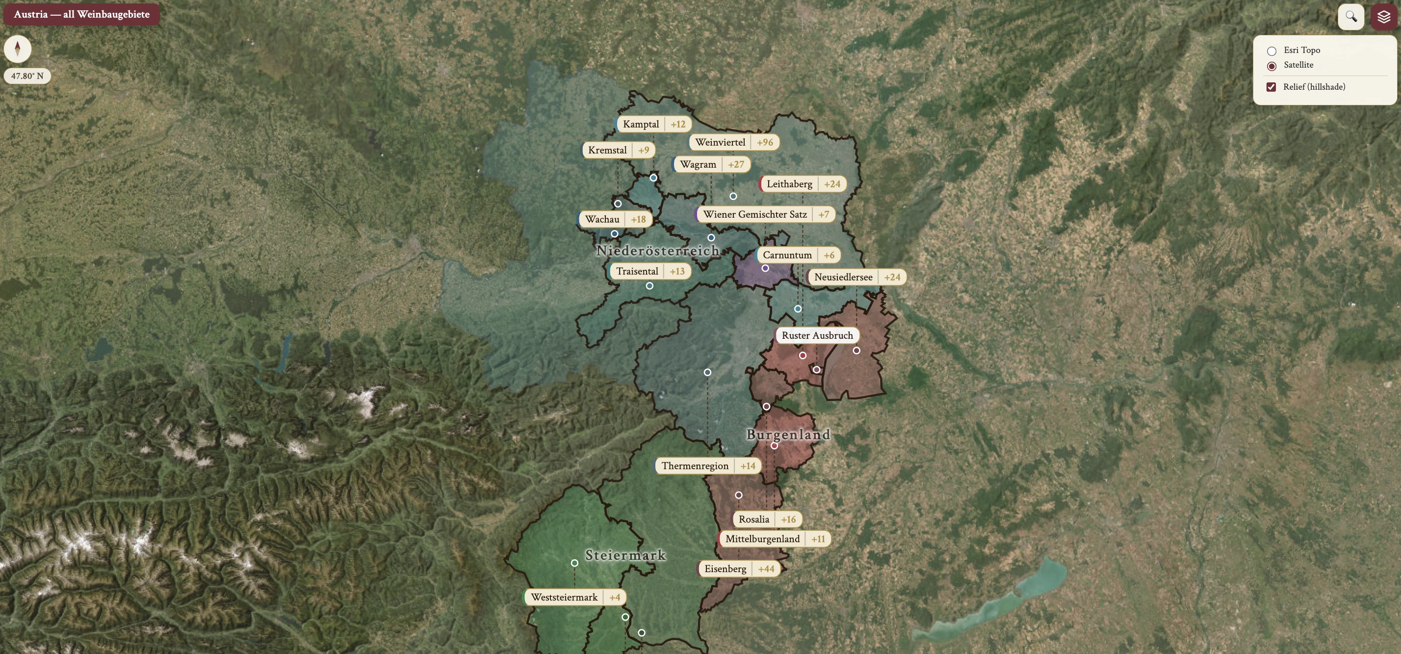
From the encyclopedia
Austria — Overview
Austria is a landlocked Central European wine country. It sits between the 47th and 48th parallels, and most of the country fits within this band; at its widest it is only 275 km north to south. It borders seven countries: Switzerland (and Liechtenstein) to the west, the Czech Republic to the north, Slovakia to the northeast, Hungary to the east and Slovenia to the south, with Germany and Italy at the north and south pinch-points.
It is best known for elegant, high-acidity Grüner Veltliner and Riesling dry whites, for world-class Blaufränkisch red wines, and for Burgenland's botrytised sweet wines — BA, Ausbruch and TBA. The identity is quality-first: over 90% of 2018 production was classified as Qualitätswein or Prädikatswein.
The modern identity is defined by the rebuild after the 1985 Glykolskandal, the diethylene glycol scandal. It led to the founding of the Austrian Wine Marketing Board (AWMB), and stricter wine law was codified.
History — Romans to the Habsburg Monarchy
The Romans bring refined viticultural skills to Austria in 15 BCE. In 79 CE the Emperor Domitian bans grapegrowing north of the Alps to drive the domestic Italian wine trade, and the Emperor Probus abolishes that 200-year ban in 277–282. Roman control ends in 488, and the vineyards are all but abandoned under Bavarian rule.
In 795 the Emperor Charlemagne issues the Capitulare de villis vel curtis imperii, setting rules for wine production. In the 10th–13th c. Cistercian monks from Burgundy significantly influence Austrian winemaking. In 1359 Rudolf IV introduces the Ungeld tax on wine, and additional tolls are imposed on wine import and transport.
Vine hectarage greatly expands over the 15th–16th c. In the 17th c. poor weather patterns and higher taxes slow the growth of the industry. Klosterneuburg Monastery establishes its wine institute in 1860, phylloxera arrives in Austria in 1872, and the first official Austrian wine law is introduced in 1907. In 1918 WWI ends and the Habsburg monarchy loses power.
History — Cooperatives to the Sekt PDO
Austria is annexed into Nazi Germany in 1938, and from 1938–1943 cooperatives experience exponential growth. Lenz Moser initiates Hochkultur training in 1950. Vinea Wachau Nobilis Districtus is formed in 1983, and 1985 brings the diethylene glycol wine scandal.
The Österreichische Traditionsweingüter (ÖTW) association is established in 1992. Austria joins the EU in 1995, Weinviertel is named the first official DAC in 2003, and the PDO structure for Sekt is announced in 2016.
The Glykolskandal and the Recovery
In the 1985 Glykolskandal certain Austrian producers illegally added diethylene glycol, a sweetening agent in antifreeze, to wines. The purpose was to boost perceived quality. Discovery led to criminal prosecutions; exports collapsed, down by four-fifths; and international loss of trust followed.
The response from 1986 onwards set the recovery in motion. It was the establishment of the Austrian Wine Marketing Board (AWMB) to restore image and maintain quality standards; a stricter wine law, with mandatory government inspection and quality certification; and an industry-wide pivot to quality-first positioning, authenticity and regional typicity.
That pivot culminated in the DAC system, proposed in 2001, approved in 2002, with the first DAC — Weinviertel — in 2003.
Geographic Structure
The structure begins with 9 federal states, grouped into 3 Weinbaugebiete, or winegrowing areas. Weinland covers Lower Austria (Niederösterreich), Burgenland and Vienna (Wien). Steirerland covers Styria (Steiermark). Bergland covers Carinthia (Kärnten), Upper Austria (Oberösterreich), Tyrol (Tirol), Vorarlberg and Salzburg.
Weinland and Steirerland together contain 17 of Austria's 18 winemaking regions. Bergland has no DACs but a long winemaking tradition and is experiencing a renaissance, growing today from only 21 ha in 1999. There are 18 DACs total — 15 in Weinland, 3 in Steirerland.
Climate — the Overall Pattern
The overall climate pattern is cool continental with pronounced regional variation. Weinviertel, the northernmost region, is influenced by cool northerly winds and has the lowest average temperature. Burgenland, near Hungary, is influenced by the warm Pannonian Plain climate and is the warmest Austrian region.
In the Danube valley — Wachau, Kremstal and Kamptal — cooler breezes come off the Alps, and the sites are moderated by Danube thermal mass and reflection. Wien (Vienna) has an urban microclimate with a warmer influence from the Pannonian Plain.
Steiermark is transitional from Mediterranean to Pannonian to Alpine climates and is influenced by the Adriatic Sea, or Illyrian, climate. Hail and spring frost hazards are common there due to continentality.
Rainfall, Disease Pressure and Organic Certification
Annual rainfall runs from 450 mm in the Weinviertel, the driest, to 850 mm in Steiermark, the wettest. Growing season rainfall is often low, especially in Niederösterreich, and irrigation may be necessary in dry years.
Disease pressure is low overall, except in Steiermark and in wet years, due to continental dryness. On organic certification, 15% of Austrian vineyard is certified organic — a relatively high proportion given cool-climate challenges.
The Rivers and the Danube
River systems — the Danube, Traisen, Kamp, Krems, Wulka and others — are crucial. Their thermal mass moderates temperature extremes. Heat reflection matters too: the water surface reflects sunlight onto the slopes, which aids ripening. Night-time warmth is a third effect, as rivers radiate stored heat during cool nights and extend the growing season. Hazard mitigation is the fourth: rivers reduce frost damage risk.
The Danube (Donau) is the single most important geographic feature in Austrian viticulture, and is most influential in Wachau, Kremstal, Kamptal and Wagram. Steep stone terraces on the north bank of the Wachau face south, which maximises sun interception, and the terrace vineyards are hand-harvested. Gneiss and loess soils enhance heat retention.
Topography
Most of western Austria is mountainous and unsuitable for commercial viticulture. The tallest peak is the Großglockner at 3,798 m, the highest in the Alps east of the Brenner Pass and part of the Hohe Tauern range.
Vineyards exist where the Alps flatten toward the Pannonian Plain and along the river valleys. In Steiermark there are steep hills and terraces, hail netting is required, and south-facing slopes are prioritised.
Warming, Hail and Terroir Preservation
The warming trend brings more reliable ripeness in cooler zones such as Wachau and Kamptal, and the potential for riper reds — a Pinot Noir renaissance. Hail and frost risk is still significant in Steiermark and other continental areas. On terroir preservation, quality-focused producers are emphasizing cool-climate elegance and mineral precision as a competitive advantage.
Grape Varieties — Overview
There are 40 approved varieties: 26 white and 14 red. By plantings in 2022 the top 5 run Grüner Veltliner, far ahead of the rest, then Zweigelt, Welschriesling, Blaufränkisch and Riesling.
The indigenous and specialty Austrian varieties, detailed below, are Grüner Veltliner, Zweigelt, Blaufränkisch, Neuburger, Roter Veltliner, Rotgipfler, Zierfandler, Sämling 88 (Scheurebe), Blauer Wildbacher, Blauburger, Blauer Portugieser, St. Laurent and Roessler.
Grüner Veltliner
Grüner Veltliner is the signature variety. Its synonyms are Green Veltliner and Weißgipfler, the Austrian name, which refers to the white woolly hair on the shoot tip. Plantings are about 33% of the total Austrian vineyard, and it is the most planted white grape globally in Austria. Its parentage is a Traminer × St. Georgener-Rebe cross.
Site specificity is real: it thrives on clay and loess soils with high water-holding capacity and struggles on dry, thin soils. Its vigour is very high on fertile soils, and canopy management is essential for ripeness and phenolic balance. It is a thick-skinned variety, and prolonged skin contact — orange and extended-contact styles — risks phenolic bitterness. Ripening is mid-season.
The aroma compound is rotundone, a sesquiterpene, responsible for the white pepper, jalapeño and herbal note that defines the variety. It is strongest in cooler sites, Weinviertel for example.
The quality tiers divide in two. Simple or acceptable QL wines are inexpensive, unoaked and for early consumption: body light to M, acidity M(+) to H, aroma citrus and green fruit, simple. Very good to outstanding QL wines are premium, pale yellow, with aging potential and mineral precision: body M to F, acidity M(+) to H, aroma citrus, peach and stone fruit, white flowers, great complexity.
Regional expression follows the site. Weinviertel DAC gives high acidity, peppery and herbal character — 'Pfefferl' — green fruit and lean structure. Wachau, in Federspiel and Smaragd, gives riper stone fruit, more generous body and complexity. Kamptal and Kremstal give a mineral backbone and good aging potential.
Welschriesling
Welschriesling's synonyms are Italian Riesling and, in Italy, Riesling Italico; it is also found in Hungary, Slovenia and Eastern Europe. It has no relation to Riesling and is a distinct variety. Plantings are about 5–6% of the Austrian vineyard, making it the second most planted white grape.
It is early ripening with high acidity. Its thin skin leaves it susceptible to noble rot (Botrytis cinerea), which is exploited in sweet-wine production. The aroma is neutral to floral in dry wines and shows pronounced tropical and dried-fruit notes in botrytised styles. In use it divides two ways: the high-acid, neutral profile is ideal for Sekt production, while botrytis-affected versions give outstanding Auslese, Beerenauslese (BA), Ausbruch and Trockenbeerenauslese (TBA).
The dry, simple tier is inexpensive, for early drinking, and its volume is declining: the region is Steiermark, the style fresh and unoaked, acidity H, aroma green and floral. The botrytised sweet tier is premium to very premium, with high aging potential, among the finest dessert wines: the region is Burgenland — Neusiedlersee and Ruster Ausbruch — the style BA and TBA, acidity H, aroma tropical, dried fruit and honeyed. The classic producer is Alois Kracher of Illmitz, Burgenland, world-renowned for TBA.
Riesling
Riesling is under 5% of the Austrian vineyard but the second most planted white in Niederösterreich, after Grüner Veltliner. Its geographic concentration is Niederösterreich, primarily warm sites along the Danube and in premium terroirs.
It is late ripening and requires the warmest sites and long growing seasons. It prefers thin soils with good drainage, of lower water retention than Grüner Veltliner. The style runs dry to fully sweet, with medium alcohol (M); high acidity persists even when fully ripe, which enables balanced sweet wines. The aroma evolves from green fruit to stone fruit to tropical depending on ripeness, and bottle-aging develops petrol or kerosene, honey, lanolin and wax.
The quality tier is very good to outstanding at a premium price, with strong aging potential. The key regions are Wachau DAC, where it is 63% of plantings and must be hand-harvested, Kremstal DAC and Kamptal DAC, where it is preferred on gneiss soils.
Zweigelt
Zweigelt's synonyms are Zweigeltrebe and Rotburger, the original name given at Klosterneuburg in 1922. Its parentage is St. Laurent × Blaufränkisch, bred by Fritz Zweigelt in 1922. Plantings are about 14% of the total vineyard, and it is the most planted black grape in Austria.
It ripens earlier than Blaufränkisch and ripens reliably across diverse sites. Its vigour is high — high-yielding and vigorous — and leaf removal and canopy management are essential for quality. The hazard is potassium deficiency, which can cause berry withering before full ripeness, so careful nutrient management is required. On disease resistance, it is not susceptible to frost or rot, and is widely planted throughout the country due to its reliability. Acidity is medium(-), tannins medium, and the fruit is deep red cherry.
The easy drinking tier is mid-priced, unoaked and fruity, with red cherry, soft and accessible: body M to M(+), tannins M. The oaked, premium tier has greater complexity and aging potential of 5–10+ years: body F, tannins M to M(+). The key regions are Burgenland, especially Neusiedlersee, where it is blended with Blaufränkisch, and Niederösterreich.
Blaufränkisch
Blaufränkisch's synonyms are Lemberger in Germany and Württemberg, Kékfrankos in Hungary and Gamé in Bulgaria. Plantings are about 5–6% of the Austrian vineyard, the second most planted black grape, and its geographic concentration is primarily Burgenland, where climate warmth is essential for ripeness.
It is early budding and late ripening; it requires warm sites and is vulnerable to spring frost. Tannins are high, acidity high, the colour deep, with black fruit. It is thick-skinned and resistant to rot, which suits it to humid areas such as the Neusiedlersee shore. Yield management decides the rest: high yields give green, unripe aromas and low phenolic ripeness, while controlled yields, for example 40–50 hl/ha, give intense, age-worthy wines.
The simple, fruity tier is mid-priced with red cherry and is approachable: body M, tannins M, oak none or little, acidity M(+) to H. The age-worthy tier is premium, with black fruit, spice and structure over 10–20+ years: body F, tannins M(+) to H, oaked, acidity M(+) to H. The key regions are Leithaberg DAC, which must be 85% Blaufränkisch and oak-aged, and Mittelburgenland DAC, which holds 51% of plantings.
Minor & Specialty White Varieties — Neuburger to Weissburgunder
Neuburger's parentage is a natural cross, Roter Veltliner × Silvaner. Its primary regions are Wachau, its birthplace at Arnsdorf, where it is used in Smaragd-level wines; Thermenregion, for full-bodied, spicy expressions; and Leithaberg, where it is a permitted white DAC grape. It is a local specialty. The body is medium-light with M(-) to M acidity, the aromas nutty — walnut and hazelnut — with age, and the mouthfeel creamy. Its acreage is declining as growers shift to Grüner Veltliner.
Rotgipfler and Zierfandler are both ancient local varieties of Thermenregion, traditionally blended as Spätrot-Rotgipfler, a regional white specialty. The body is medium-full with good acidity, and the character is herbal or nutty. Quality is good to very good, at mid to premium price.
Roter Veltliner, the Red Veltliner, is local to Wagram DAC and has no relation to Grüner Veltliner. It is full-bodied with M to M(+) acidity and nutty aromas that develop with bottle age. Quality is good to very good, mid to premium.
Weissburgunder — Pinot Blanc — is soft and delicate, with citrus to stone fruit aromas and M(+) acidity. It is used in Leithaberg DAC blends.
Minor & Specialty White Varieties — Sämling 88 to PIWI
Sämling 88, or Scheurebe, is a Riesling × Bukettraube cross. The name origin is Georg Scheu's 88th seedling at the Landesanstalt für Rebenzüchtung in Alzey. It is aromatic, with cassis and grapefruit notes, and is used in dry and sweet wines.
Sauvignon Blanc, Weißwein on the label, is increasingly planted in Steiermark — Südsteiermark — and in warmer sites, and accounts for 18% of Steiermark plantings. It is crisp and herbaceous with good acidity.
The creator of Müller-Thurgau was Hermann Müller, in 1882 at Geisenheim, from the Canton of Thurgau, Switzerland. Its parentage is a Riesling × Madeleine Royale cross.
Muskateller, Chardonnay and Grauburgunder (Pinot Gris) are emerging white varieties with limited but growing plantings, especially in warmer regions. Chardonnay is used in premium oaked expressions among Baden and Burgundy-style producers, and its Austrian synonyms are Morillon in Steiermark and Feinburgunder in Wachau.
The PIWI varieties — Pilzwiderstandsfähige — are fungus-resistant interspecific hybrids such as Solaris and Regent. Austria is actively developing these to reduce pesticide use. They are notable for sustainability and have a growing presence in certified-organic and biodynamic estates.
St. Laurent and Pinot Noir
St. Laurent's synonym is Sankt Laurent. Its naming points to St. Lawrence's Day, August 10th, when the grape berries begin to change colour; St. Lawrence, who died in 258 in Rome, is the patron saint of the poor and of cooks. Its parentage records no verifiable parents, though it shows genetic proximity to the Pinot family — a thicker-skinned Pinot Noir relative that ripens earlier.
The body is medium(-), tannins medium, sugars and alcohol moderate. The flavour is Morello cherry, and acidity is retained even after MLF. It is often oaked for added spice and complexity, and it is compared to red Burgundy for elegance, red fruit and tertiary woodsy traits.
It is a finicky vine. Its hazards are early-season flower drop, or coulure; botrytis bunch rot; downy mildew; and naturally high pH, which brings Brettanomyces risk in the cellar. Its specialty regions are Thermenregion, with free-draining warm soils and the historic stronghold, and Northern Burgenland. Quality is good to very good, mid-priced.
Pinot Noir's synonym is Spätburgunder, the German name. Interest is increasing in warmer zones and at premium level, with early high-profile examples from Kamptal. The top regions are Gols (Neusiedlersee), Kamptal and Thermenregion.
Blauburger, Blauer Portugieser and Roessler
Blauburger's parentage is Blauer Portugieser × Blaufränkisch, created in 1923 by Fritz Zweigelt at Klosterneuburg. The aim was an early- to mid-ripening red variety suited to areas otherwise better for white grapes. It is seldom seen alone, being low in acid and low in tannin, and is valued as a deep-coloured blending grape. Its distribution is mostly Weinviertel, with scattered plantings in Lower Austria and a small amount in Burgenland.
Blauer Portugieser is a Blauer Zimmettraube × Silvaner cross. The legend is that it was reputedly brought from Porto to Bad Vöslau in 1772 by Baron von Fries, the Austrian ambassador. DNA evidence suggests Austrian origin, and the Portuguese name is possibly a translation of the Austrian original. Nearly all of it is found in Lower Austria, the vast majority in the Weinviertel, and plantings are declining. Typical yields produce lighter-coloured reds, low in acidity and personality.
Roessler — synonyms Roesler and Roezler — is a deep-coloured blending partner. It contributes colour, dark forest-berry fruit, extract, body and tannins to blends with Pinot Noir, Blaufränkisch, Zweigelt and St. Laurent.
Viticulture — Training Systems
The Lenz Moser system was the high-volume production method and the 1980s standard: wide rows to avoid shading, minimal maintenance, and suitable for mechanisation. It is increasingly replaced by Guyot among quality-focused producers. It was developed by Dr Lenz Moser in the 1950s, with wire trellising.
Single or double Guyot with VSP — vertical shoot positioning — is the high-quality production standard today. It allows precise canopy management, air flow and selective ripeness.
The Lyra, or Lyre, trellis system is a Y-shaped vine training. It increases leaf canopy and allows quick drying of leaf and grape after rain, and it is very difficult to maintain. It is used notably by Bründlmayer on about 20% of the Heiligenstein vineyard for his 'Lyra' Riesling bottling.
Yields, Canopy Management and Harvest
The maximum legal yield is 67.5 hl/ha, with an average of 54 hl/ha from 2017–2021. Prädikatswein runs at lower yields, typically around 40–50 hl/ha, and DAC wines are closely monitored for typicity.
Canopy management is essential for Grüner Veltliner, for phenolic ripeness, and for Zweigelt, for tannin development. Leaf removal in summer gives sun exposure on the grapes, and air flow gives disease prevention.
Hand harvest is mandatory in Wachau DAC at all levels and standard on the steep terraces of Wachau, Kremstal and Kamptal. It is labour-intensive and adds cost, and it is essential for quality and for selective botrytis picking. Machine harvest is common on flatter lands, in Weinviertel and Burgenland.
Hazards
The hazards are spring frost, hail, winter freeze and water stress. Spring frost is common across many regions, and rivers and altitude assist mitigation. Hail falls particularly in Steiermark, from continentality, and netting is required in high-risk areas.
Winter freeze is rare but possible in extreme cold years, and less critical than in Germany due to marginally warmer average winters. Water stress comes from low rainfall during the growing season, especially in Niederösterreich, where irrigation may be necessary.
Winemaking — White Wine Philosophy
The white wine philosophy is preservation: primary fruit and varietal character preservation is paramount. Short periods of skin contact are common, hours to days, and the purpose is to maximize aromatic compounds and texture. Fermentation runs in neutral vessels — stainless steel and old wood — with precise temperature control, which prevents loss of the delicate aromas.
Malolactic fermentation (MLF) is not common for Grüner Veltliner and Riesling. It is prevented by naturally low pH or by design choice, the reason being that MLF masks varietal character.
Maturation vessels divide the same way: stainless steel retains fruit, and old wood adds texture without oak flavour. Lees contact is common and valued, and 6 months or longer adds texture, complexity and mineral precision. On final dryness, most wines are fermented to dryness, though some retain 1–5 g/L RS for balance.
Winemaking — Red Wines, Acacia and Amphorae
Red fermentation is in large open-top fermenters, with punch downs or pump overs for colour and tannin extraction. Some producers work with ambient yeast and wild fermentation.
Maturation is in stainless steel or large old oak of 300–600 L and above, which softens tannins without oak flavour and retains primary fruit. Barriques are reserved for premium wines. There is some new oak usage, but less common than in Burgundy or Spain. Acacia vats are used by some producers for both white and red; they allow small oxygen ingress without vanilla oak flavour.
Orange, or extended skin contact, wine comes from prolonged maceration on skins, an emerging trend in Vienna (Gemischter Satz) and among selected producers. Amphorae are used for fermentation and aging in clay amphora vessels, a small but visible movement among artisanal producers.
Sturm, Schilfwein and Uhudler
Sturm is partially fermented, sparkling grape juice — 'half-fermented' — made from grapes harvested and pressed exclusively in Austria. It is sold in autumn for immediate consumption and is common across Austria, especially associated with the south and Heurigen culture. Set against it is Traubenmost, unfermented grape must, or grape juice.
Schilfwein, reed wine, is a sweet wine made by drying grapes on reed mats — Schilf means reed — analogous to Strohwein but using reeds instead of straw. It was created by Willi Opitz in 1989 in Illmitz, in the Seewinkel of Neusiedlersee, Burgenland. Drying takes 3–6 months and yields only about 7 hl/ha. Opitz collects the reeds from the Neusiedlersee, and the notable wine is Opitz One, a Zweigelt Schilfwein.
Uhudler is often rosé and white, made from non-vinifera and hybrid grape varieties, and is found in the southern part of Burgenland. It is a folk-wine tradition distinct from mainstream Austrian quality wine.
Botrytis, Eiswein and the Sweet Prädikat
Austria is renowned for world-class botrytised and noble sweet wines, particularly from Neusiedlersee, Ruster Ausbruch and other Burgenland regions. The Lake Neusiedl botrytis pattern — a unique fog-and-sun microclimate — ensures consistent noble rot in every vintage, a rarity for botrytis-dependent wines.
The sweet Prädikat hierarchy runs Auslese, then BA, then Ausbruch, uniquely Austrian and especially Rust, then TBA, of extreme must weight at 30° KMW and the deepest aging potential. Eiswein is a separate Prädikat: fresh, high-acid, with peach and grapefruit character, an alternative to botrytis. Strohwein and Schilfwein are straw- and reed-dried raisin wines, rare and specialist.
Botrytis-affected grapes for BA, Ausbruch and TBA go through slow, natural fermentation from very high must weights. Fermentation often stops naturally at 5.5–8% abv, which leaves high residual sugar of 100–300+ g/L.
Eiswein grapes are harvested at or below −7 °C and pressed while frozen. The juice is highly concentrated, high in sugar and acidity, with pure peach and grapefruit character. No artificial freezing is permitted.
Warm years — 2015, 2018, 2019, 2022, 2023 — give fuller ripeness and more reliable botrytis. Cool years — 2010, 2014, 2017 — give leaner wines, higher acidity and longer aging.
On the map
- Niederösterreich — eight DAC
- Burgenland — six DAC
- Steiermark — three DAC
- Wien — Wiener Gemischter Satz