Douro — Wine Region Guide
The Douro maps from Your Own Wine Encyclopedia — every name tag opens a study card. Below, the chapter's own geography, climate and geology notes.
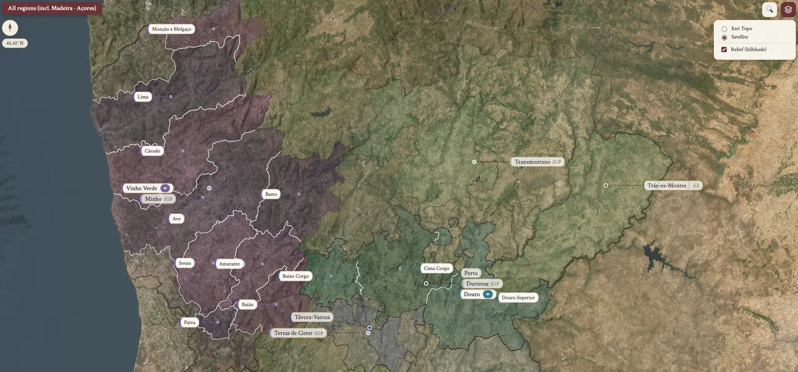
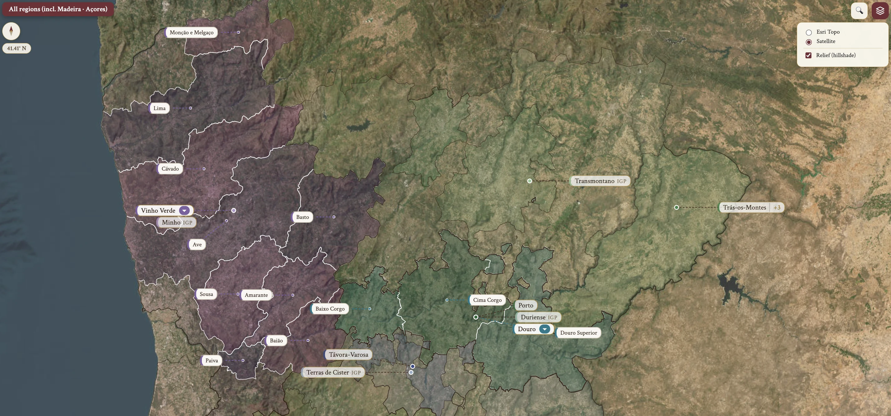
From the encyclopedia
Overview
The Douro is the most famous wine region in Portugal and the largest wine-producing region, though Vinho Verde has the largest single DOP area. The registered DOP area is approximately 41,000 ha.
History — Port, Bordeaux and Barca Velha
Port carries high alcohol and residual sugar, and that makes it preservable for international market export.
In the late 1930s Fernando Nicolau de Almeida traveled to Bordeaux, where the first growths inspired him to create a competitive Douro table wine. He chose Douro Superior for its higher elevations and its granite soils, which offer more freshness.
In 1947 the agronomist Álvaro Moreira da Fonseca published an exhaustive classification of every vineyard in the Douro, grading them A (highest) to I (lowest). That classification is still used today.
Barca Velha followed in 1952 — the first vintage, created by Fernando Nicolau de Almeida at Casa Ferreirinha/Sogrape from Tinta Roriz, which is Tempranillo, with other indigenous varieties. It was initially unpopular and now fetches super-premium prices; it is the pioneer of the dry Douro red style.
History — the modern era
In 1976 João Nicolau de Almeida, son of Fernando, released a study that planted a dozen varieties across the subzones over five years. It resulted in five top varieties — Touriga Nacional, Touriga Franca, Tinta Cão, Tinta Roriz and Tinta Barroca — and these have dominated new plantings since.
The unfortified Douro DOP was established in 1982; the wine had always existed, but the official DOP came late. EU entry in 1986 provided funds for investment in modern winemaking equipment, and Douro estate owners gained the right to export Port directly from their Quintas — previously all Port was exported only from the Vila Nova de Gaia shipper warehouses. DOP establishment came in 1998.
Climate and the mountains
The demarcated region runs along the Douro river for over 100 km, from the Spain border to Mesão Frio, 100 km inland from Oporto. The climate is warm continental — Serra do Marão blocks Atlantic weather — and the valley is excessively dry and increasingly drought-prone.
Two mountains stand on the route from Oporto to the Douro Valley. Serra do Marão lies north of the Douro river, is granite, and blocks Atlantic rain from the west. Serra de Montemuro lies south of the Douro river, to the southwest; together with Marão it creates the continental rain-shadow climate.
The three sub-regions
Of the sub-regions, Douro Superior — the Upper Douro — is the largest, hottest and driest, with annual rainfall of 450 mm. It is often used for Vintage Port and for unfortified styles, and the Sabor tributary runs through it.
Cima Corgo is warmer and drier, with annual rainfall of 700 mm, and it holds the largest total vineyard area. Its major city is Pinhão, the heart of the demarcated Douro, and the Tua tributary is here.
Baixo Corgo is the coolest and wettest, with annual rainfall of 900 mm. It has the highest planting density and the largest production volume, and its major cities are Lamego and Peso da Régua.
Vineyards along the tributary rivers are being reexamined as exciting sites for table wine production: higher elevations, more east/west expositions, greater granite concentrations.
Soil
The bedrock is schist, under a shallow topsoil of weathered schist. It is low in organics, stony, and low in water retention. Schist splits into vertical layers, and the grape vines penetrate them to search for water.
Grape Varieties — Touriga Franca, Touriga Nacional, Tinta Roriz
The reds are usually blends; single varieties are rare.
Touriga Franca is the most widely planted, and it is late-ripening. It prefers the warmest sites — low altitude, south-facing — and its thick skins and tight bunches give fungal resistance. It is vigorous and requires summer pruning. It brings color, tannin and acidity, with juicy red/black fruit and floral aromas.
Touriga Nacional is second, and mid-ripening. Thick skins give deep color and high tannins, and acidity is well-preserved; the wine shows concentrated black fruit and floral aromas with long-aging potential. Excessive vegetative vigor calls for summer pruning, and the variety is susceptible to coulure, which gives low yields and vine imbalance.
Tinta Roriz — Tempranillo — is early-ripening and prefers relatively cool sites, which avoids water stress. It contributes body and deep color. High yields are possible, so they must be limited to maintain concentration.
Grape Varieties — Tinta Barroca, Tinto Cão, Sousão
Tinta Barroca is the third most planted, and early-ripening. It takes the coolest sites — altitude, north-facing — mainly in Baixo Corgo and Cima Corgo, and it is susceptible to heat damage and grape drying. It is less floral and more earthy, and its acidity and color fade quickly if it is not in cool areas.
Tinto Cão is late-ripening and very heat-resistant. It is low yielding, with small thick skins that are fungal resistant, and it gives concentrated wine, high acidity and good aging potential.
Sousão has thick skins and deep color. Its acidity is well-preserved, which keeps freshness even in warm years, and it is recently increasing in plantings.
Grape Varieties — the whites
Among the white varieties, Viosinho is full-bodied, floral and stone fruit, with a possible acidity deficiency. Rabigato gives high acidity, citrus and floral character. Gouveio, which is Godello in Spain, has M(+) acidity with citrus and stone fruit.
Moscatel Galego Branco — Muscat Blanc à Petits Grains — is used for enhancing aroma intensity, and it is grown in the highest-altitude vineyards, where cool day/night conditions bring acidity preservation. The others are Esgana Cão (Sercial), Malvasia Fina and Arinto.
Viticulture — Socalcos and patamares
Many slopes run over 30%, and those steep slopes limit the possible vineyard layouts. There are 3 types of vineyard layouts.
Socalcos, the traditional terraces, carry about 6,000 vines/ha on dry stone wall support. Mechanization is impossible on them — the terraces are narrow and the walls need maintenance — and they are UNESCO protected, so they cannot be converted to another layout. The modern adjustment has been reduced density to allow small tractors. 50% are still maintained as Socalcos.
Patamares, the earth-bank terraces, carry about 3,000–3,500 vines/ha, with steep earth banks instead of stone walls, so small tractors can traverse the slopes diagonally. They are cheaper than Socalcos but bring erosion and weed problems. The large, wide form takes 2 rows per terrace, which brings uneven ripening issues; the narrow modern form takes 1 row per terrace, built with bulldozers and laser technology, which gives improved drainage and reduced erosion.
Viticulture — Vinha ao Alto
Vinha ao Alto, the vertical rows, carries about 5,000 vines/ha. The rows run vertically along the slope, and it is the cheapest to plant and maintain. Over 40% slope, mechanization is impossible, so patamares are preferred. Severe water runoff and erosion keep its use relatively limited. Ferreira and Ramos Pinto were the pioneers in the 70s–80s.
Training, canopy and rootstocks
Vine training is cordon/spur-pruned or head-trained/cane-pruned, on VSP trellising. Summer pruning means leaf removal, especially for the late-ripening varieties, and canopy management answers downy mildew and botrytis.
Rootstocks are drought-resistant, mainly 110R and 1103P, which are V. rupestris × V. berlandieri hybrids. Replanting focuses on increased density, a mechanizable layout, and optimal selection of planting materials — varieties and rootstocks.
Water and soil management
The Douro was traditionally unirrigated. In 2019 IVDP regulations were relaxed and irrigation became allowed if water stress threatens quality, with only an IVDP notification required. Fungicides handle fungal disease control, especially in the humid Baixo Corgo.
Cover crops are grown on the Vinha ao Alto slopes, which gives erosion prevention, soil structure and nutrient improvement, and weed reduction. Sustainable and organic farming is increasingly adopted among large producers and growers.
Hazards
The hazards run through the season. Late spring frosts reach the highest altitude vineyards. Cool, humid weather from the west interferes with flowering and fruit set, especially in Baixo Corgo, and downy mildew and botrytis bunch rot are a problem there as well. Drought is answered by permitted irrigation, and erosion by cover crops.
Harvesting
Hand harvesting is primarily used, because the terrain is unsuitable for mechanization, and there is a labor shortage from aging and rural exodus. Symington Family Estates has been developing suitable mechanical harvesting since 2015.
The harvest period is spread over weeks, starting in Douro Superior and ending in Baixo Corgo — a matter of microclimate, variety, and hand-harvest differences.
Winemaking — red
Destemming is common in red winemaking: the high tannins of the Douro varieties mean the winery avoids additional tannins and green flavors. Fermentation is mainly in stainless steel, temperature-controlled, at a relatively low temperature of 24–28°C, which controls tannin extraction.
Lagares are the traditional vessel — wide, shallow lagares, primarily for Port. Some producers blend in small-batch lagar fermentation, or start fermentation in lagares and monitor extraction levels.
After fermentation the handling splits. Easy-drinking wines are pressed immediately after fermentation completion; aging wines get post-fermentation maceration, for tannin extraction and softening. Maturation was traditionally in large Portuguese oak; the modern vessel is the barrique, with French oak preferred. The trend is toward larger vessels of 400–500 L and reduced new oak, to preserve fruit flavors.
Winemaking — white, rosé and blending
In white winemaking the inexpensive wines see cool fermentation in stainless steel, with light–medium aromas and M–M(+) acidity, and Moscatel Galego Branco is used for aroma enhancement. Premium whites come from old vine grapes, with oak fermentation and aging, giving more intense aromas and more body and texture; the example given is Niepoort's Redoma Reserva Branco.
Rosé sees limited skin maceration time and is mostly simple, for young drinking. Blending works on two levels: grape blending across multiple varieties, and site blending, where diverse locations are sourced for balanced ripeness and to mitigate weather variation. North-facing is cool, high altitude is cool, coastal proximity is cool.