Portugal — Wine Region Guide
The Portugal maps from Your Own Wine Encyclopedia — every name tag opens a study card. Below, the chapter's own geography, climate and geology notes.
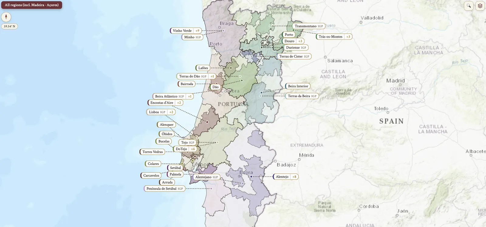
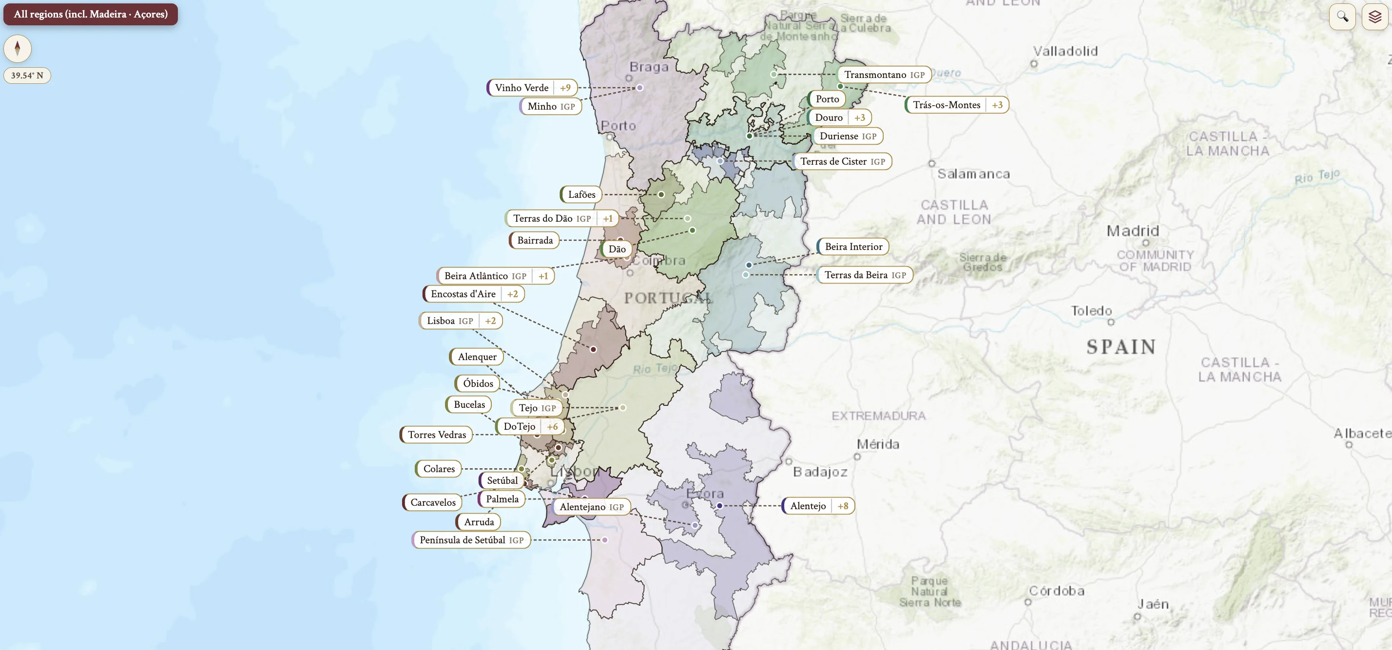
From the encyclopedia
Overview
Portugal is the westernmost country in continental Europe, bordered by the Atlantic Ocean to the west and south, and by Spain to the north and east. Port and Madeira are the famous fortified wines, but most grapes are produced as unfortified still wines, and red wines are produced in larger quantities than white wines.
The Catálogo Nacional de Variedades de Videira of 2017 catalogued 262 indigenous varieties, yet about 55% of vineyard area is planted to just 10 varieties. Traditional field blends survive in the mountainous interior, where dozens of varieties are co-planted; they are now a small percentage of production but culturally important.
Vine Area, Production and the Cork Industry
Vineyard area as of 2021 stood at 192,000 ha, having decreased by 84,000 ha over 30 years. Average total wine production is approximately 6.5 million hL, which includes fortified and sparkling; estimated production of unfortified still wines is approximately 5.5 million hL. Between 2011 and 2021 production varied within 600–740 million liters, depending on weather conditions. Mainland Portugal accounts for 99% of wine production, the remainder coming from Madeira and Açores, and as of that year the country was the 10th largest wine producer and exporter in the world by volume.
The economic importance of grape growing is unusual. Grape cultivation accounts for 35% of Portugal's total agricultural production, the world's highest ratio.
Wine cork is produced from Quercus suber, the cork oak. Post-phylloxera many vineyards were left unplanted, and the cork industry took root in Portugal during this period, making the country the major world wine industry cork closure supplier.
Portuguese Wine Terms — Types and Labeling
Portuguese wine terms begin with vinho itself. Vinho is wine, and also the designation for uncertified wine with no DOP or IGP. Vinho Branco is white wine and Vinho Tinto is red wine. Vinho Tranquilo is still, or table, wine — as opposed to sparkling or fortified. Vinho Espumante is sparkling wine, its second fermentation taking place in bottle by the traditional method or in a closed vat by the continuous method. Vinho Generoso, or Licoroso, is fortified wine, with alcohol or wine brandy added during winemaking to arrest fermentation. Vinho Varietal is a wine made from a single variety, or with absolute dominance of one variety.
Two older styles carry names of their own. Palhete is a traditional light red or rosé style, made by mixed fermentation of white and red grapes. Abafado — “muffled” or “stifled” wine — has aguardente added during fermentation, leaving it sweet with high alcohol at 17–20%.
Casta is grape variety. Colheita is the vintage, the date of harvest, and Colheita Tardia is late harvest, an official designation for DOC/DOP and IGP wine.
Portuguese Wine Terms — Sweetness, Sparkling and Quality
Sweetness and sparkling terms are fixed by sugar. Seco is dry, wines with sugar < 4 g/L. Meio Seco is medium dry, used of sparkling wines with residual sugar 33–50 g/L. Doce is sweet, wine containing > 50 g/L reducing sugars. Bruto is brut, sparkling wine with sugar dosage < 12 g/L.
The Portuguese quality classification system runs on its own vocabulary. DOC in Portugal, DOP in the EU, is the highest official quality category, with region-specific rules. Vinho Regional in Portugal, IGP in the EU, has wider rules, and is often used by top-quality wines that do not fit DOP requirements.
Reserva is a designation of superior quality for DOP wines, certified by a certification body. Grande Reserva means highlighted organoleptic characteristics and alcoholic strength ≥ 1% vol. above the minimum, and requires a harvest year. Garrafeira is a harvest year plus a minimum aging designation, and also means a wine shop or cellar. Selecção do Enólogo, winemaker selection, is an unofficial designation, and estágio is aging in bottle or cask.
Portuguese Wine Terms — Cellar, Estate and Institutions
Winemaking, its infrastructure and its by-products have terms of their own. An adega is a winery or cellar. A quinta or herdade is a wine estate or property — quinta in the north, herdade in the south. A lagar is a fermentation vat, often shallow, of granite, marble, concrete or stainless steel, in which grapes are trodden by foot or mechanically. Bagaceira is grape marc spirit, a pomace brandy made from skins, pips and residuals after pressing.
Two institutions stand above the trade. The IVV, Instituto da Vinha e do Vinho, is the Portuguese public vine and wine institute; the CVR, Comissão Vitivinícola Regional, is the regional wine commission.
History — from the Tagus and Sado to the Marquis of Pombal
Wine cultivation begins around ~2000 BC in the Tagus and Sado valleys, under the Tartessians, Phoenicians, Greeks and Romans. In 1250 Portugal expelled the Moors and established a national identity. The alliance with England was written down twice: the Treaty of Windsor of 1386 was a diplomatic alliance, opening paths for wine trade, and has run 600+ years; the Treaty of Methuen of 1703 granted preferential tariffs on Portuguese wines.
In 1756 the Marquis of Pombal established the Companhia Geral da Agricultura das Vinhas do Alto Douro — the Real Companhia Velha, Portugal's oldest wine company. It was the world's first official wine origin control system, marked on the ground with boundary stones, the marcos pombalinos. 335 of the finest vineyards were classified as Feitoria, Vinho de Feitoria for export, the remainder as Rama for domestic consumption. That authority is currently inherited by the IVDP, the Instituto dos Vinhos do Douro e do Porto.
History — Phylloxera, the Região Demarcada and the Cooperatives
In the 19th C the Peninsular Wars and the Portuguese Civil War affected wine production adversely, while the rising popularity of French and Spanish wines cost market share. Phylloxera arrived in 1867 and devastated many Portuguese wine regions. A royal decree of 1908 established 7 wine regions — Bucelas, Colares, Carcavelos, Dão, Madeira, Moscatel de Setúbal and Vinho Verde — and the Região Demarcada system was introduced in 1929.
Salazar's rule from 1932 ran 40 years and favored cooperatives. Over 100 cooperatives were established in the 1950–60s, and the equipment shortage and large-volume, low-quality wine that followed damaged the reputation of Portuguese wine. Dão was particularly hard hit, one of the first regions forced into cooperative production. The Junta Nacional do Vinho, the JNV, had been established in 1937, and it integrated small vineyards into the cooperative network.
Mateus Rosé was launched in 1942, created by Fernando van Zeller Guedes, and Lancers Rosé followed in 1944. By the late 1980s Mateus Rosé, with its white version, accounted for over 40% of Portugal's unfortified still wine exports.
History — Carnation Revolution, EU Entry and Today
The Carnation Revolution of 1974 was the return to democracy. EU entry in 1986 removed production and trade restrictions. Low-interest loans and subsidies let producers independently produce and market wine; cooperatives either adapted or closed. EU funds modernized infrastructure, research, education and modern equipment, temperature-controlled stainless steel tanks among it, and small estates — quintas — disassociated themselves from the cooperatives and began their own production.
The debt crisis and austerity of 2011–2014 made export market development essential. Today well-ripened reds and fresh whites at affordable price points, together with many unique indigenous varieties, secure Portuguese wine's position on the world stage.
Climate & Topography — the Coast and the Mountains
Portugal divides into 4 geographic zones. The Coast, in the west, is maritime, and its regions are Lisboa and Bairrada. Between Lisbon and Porto the continental shelf nearly disappears, which gives one of Europe's deepest and coldest coastlines. The cold humid air is constant, morning fog with it, and the mountains to the east trap the moisture. North of Porto the shelf extends again, so the maritime influence on Vinho Verde is slightly weaker; but the higher mountains make an extreme rain shadow, and that makes one of Europe's wettest growing regions.
The Mountains are the north interior, and the climate there is continental: Douro, Dão, Trás-os-Montes and Beira Interior. Giant granitic mountains carry schist at lower elevations, and vineyards lie above 1,000 m. The soils are extremely poor, and the diurnal swings are large.
Climate & Topography — the Savannah and the Islands
South of the Tagus the Savannah is Mediterranean, and its regions are Alentejo, Tejo, Setúbal and the Algarve. Rolling plains of rich red clay carry diverse agriculture — grains, cork and livestock. Summers are hot, but the diurnal shift is large, a difference of 22–28°C.
The Islands, Madeira and Açores, are extreme maritime. Their soils are volcanic, the climate temperate at 10–25°C, and the growing seasons long.
Soil
Schist or granite carries the mountain regions — Vinho Verde, Douro, Dão — and the hillsides of Alentejo. Bairrada, Lisboa, Tejo and the Península de Setúbal have diverse soils: limestone-containing clays and sandy soils. Alluvial soils, fertile, lie around the river banks, as in Tejo.
Grape Varieties — Top Plantings, Aragonez and Touriga Franca
By vineyard area the top plantings run in this order: Aragonez (Tinta Roriz), Touriga Franca, Touriga Nacional, Fernão Pires (Maria Gomes), Castelão, Trincadeira, Baga, Loureiro, Arinto (Pedernã), Syrah, Roupeiro, Alicante Bouschet.
Aragonez, or Tinta Roriz, is Tempranillo. It is the most widely planted variety in Portugal, with a total planted area of 21,150 ha, and it is particularly dominant in the Douro Valley alongside Touriga Franca.
Touriga Franca is the most planted red in the Douro. It is late ripening and prefers the warmest sites, and it gives red and purple fruit, floral character and soft tannins. It is favored by Port producers for its reliability.
Grape Varieties — Touriga Nacional, Castelão and Fernão Pires
Touriga Nacional is originally from Dão and is the most important quality red. It gives bergamot, orange zest, rose petals and graphite, and it is intensely tannic with high acidity. It is susceptible to coulure, which lowers yields. Its synonyms are Bical Tinto and Mortágua Preto.
Castelão is the most widely planted red casta — adaptable, full-bodied and tannic, with meaty red-fruit aromas. It is mainly grown in the Península de Setúbal, with small amounts in Lisboa, Alentejo and Tejo.
Fernão Pires is the most widely planted white grape variety in Portugal. In Bairrada it is called Maria Gomes.
Grape Varieties — Baga, Alvarinho and Encruzado
Baga is the key red of Bairrada. It is late-ripening and vigorous, and historically astringent, though climate change is helping it — warmer seasons, less September rain. It gives red and black fruit, flowers and smoky minerality, and it is also used for traditional method sparkling.
Alvarinho, Albariño in Spain, likely originated on the Portugal-Spain border, in southern Galicia and northern Vinho Verde. It is mid-budding and mid-ripening with thick skins, and gives citrus, stone fruit, herbal and floral character. It is most famous in the varietal wines of Monção e Melgaço.
Encruzado is the dominant white grape in Dão. It is early to mid-ripening, and gives citrus, pomaceous fruit, rose and flint. It is increasingly made in a Burgundian style, fermented and aged in French barrel.
Grape Varieties — Alicante Bouschet, Synonyms and International Varieties
Alicante Bouschet is a teinturier, developed in France by Henri Bouschet in 1855. In Portugal it is a key component of ambitious Alentejo reds, not just a color-add as in Spain and France.
The synonyms and terms cross borders. Trincadeira is Tinta Amarela. Jaen is Mencía in Spain. Bastardo is Trousseau in France. Sercial is Esgana Cão in inland regions. Casta is the Portuguese word for grape variety.
International varieties — Syrah, Cabernet Sauvignon and others — are planted in various regions. The permitted regions are Tejo, Alentejo, Bairrada, Lisboa and certain sub-regions of the Península de Setúbal. They are not permitted in Douro, Dão and Vinho Verde.
Grape Varieties — Recent Trends and Blends
Alentejo, Lisboa and Tejo historically relied on international varieties as an export strategy. Currently the trend is increasing toward returning to indigenous Portuguese varieties, and small-scale artisan producers are reviving those varieties.
Most wines are blends of multiple varieties. The exceptions, made with single varieties, are Baga in Bairrada, Encruzado in Dão and Alvarinho in Monção e Melgaço, Vinho Verde.
Viticulture — Vine Training and Modern Vineyards
The most common vine training is cordon or replacement-cane, VSP trellised. A significant proportion of old bush vines remains — in the Douro, in parts of Alentejo, and on a small scale in Dão and Bairrada — and these produce 'field blend' wines. The traditional training is Enforcado, a high-trained pergola, traditional in Vinho Verde.
Modern vineyards were established from the 1980s onward, planted with single varieties or with variety blocks.
Viticulture — Irrigation and Organic Certification
Irrigation generally no longer requires authorization; it is regulated at regional level. For example, Douro producers notify the IVDP.
Approximately 4,000 ha — 2% — is certified organic, with additional conversion underway. Some producers practise organic methods without certification, on cost-benefit considerations.
Hazards
Climate change is the first of the hazards: drought, and extreme weather events — hail, storms, wildfires. The coastal challenges are different. Humid weather gives poor fruit set and fungal disease risk. The common issues in the vineyard are esca and the European Grapevine Moth.
Winemaking — Modernization Post-EU
Post-EU, from 1986 onwards, came major modernization of winemaking equipment and techniques. Protective winemaking in temperature-controlled stainless steel tanks gives fruit-forward wines, especially white. De-stemming equipment improved tannin management in red wines. The adoption of French oak aging made it the main oak type, with some American oak used.
Winemaking — Traditional Techniques
Some producers maintain traditional methods and techniques. Large Portuguese oak and Brazilian hardwood toneis of 3,000–6,000 L are used primarily by premium wineries in Bairrada. Lagares — shallow fermentation vats made of schist, granite or marble — are associated with Port winemaking.
Winemaking — Recent Trends and Modern Winemakers
Moderation in oak use is one recent trend: reduction of new oak and of oak aging periods, in line with the global trend. Producers purchase new foudres of 2,000–2,500 L and wooden fermenters from France, Italy and Austria, and there is a resurgence of the niche for large wooden vessels, the toneis. Experimentation with Portuguese oak and chestnut barrels runs alongside it.
The rising popularity of fermentation and aging in clay vessels has given DOP Vinho de Talha in Alentejo. Pre-fermentation skin contact is used for premium white wines, for texture and flavor intensity, and there is a revival of skin fermentation for white wines, with the growth of natural wine alongside it.
Modern winemakers bring broader international experience and improved winemaking, packaging and marketing, with a deeper awareness of indigenous varieties and traditional techniques.
On the map
- Portugal — Mainland
- Mainland North
- Mainland Centre
- Mainland South
- Madeira
- Açores
- Vinho Verde
- Douro · Porto
- Dão
- Bairrada
- Beira Interior
- Bucelas
- Colares
- Alenquer
- Setúbal · Palmela
- DoTejo · Tejo
- Alentejo
- Pico